
Based on the traditional hydrological monitoring research, this paper proposes a design scheme of hydrological information remote monitoring and management system based on single chip microcomputer and GPRS network. The scheme uses the short message service of GPRS network to complete the wireless and remote parameters of water level, temperature and other parameters. Real-time transmission, computer management of measurement results, high measurement accuracy. The actual use proves that the system has high stability and practicability, which provides a scientific basis for scientific development and rational use of groundwater resources, effective prevention of land subsidence and development of ground fissures and government decision-making.
0 Preface
Hydrological information is an important indicator for measuring water resources. The change of groundwater level is closely related to groundwater exploitation and land subsidence, and is of great significance for controlling land subsidence. Traditional hydrological monitoring mainly relies on manual and semi-manual monitoring methods, which causes problems such as large workload, low efficiency, complicated and error-prone data processing, and poor timeliness of information transmission. It neither adapts to the development of informationization nor meets the requirements of modern management. need. Moreover, the labor intensity is also very large, and the measurement accuracy cannot be guaranteed, especially monitoring some monitoring points with relatively remote or scattered geographical locations, and the work is more difficult.
In order to make rational use of water resources, fully understand the status of water resources in various river basins, realize automatic monitoring and remote management of hydrological information, and rationally use computer technology, high-precision measuring instruments, public communication platforms and other tools to realize remote real-time synchronization of hydrological information. Dynamic monitoring is important.
With the development of wireless communication technology, the process of informationization in China has been continuously promoted, and the requirements for informationization in various industries have become higher and higher. In the understanding of informationization, from the simple digitalization to the digitalization and networking, wireless The height of the unity. Compared with the current requirements of informationization, although the original cable system has basically completed digitization and networking, its complicated wiring and high maintenance cost make the network nodes unable to be widely popularized, which has caused the in-depth and development of informationization. Great limit. Therefore, the demand for information technology for wireless data transmission technology is increasing. Nowadays, the mobile network covers a wide range, and the various data services provided by it enable many smart devices and meters to realize the remote transmission of wireless data. GPRS is a general-purpose system wireless service with high reliability and relatively low cost. In addition, GPRS-based systems can effectively simplify the ground facilities of the monitoring system.
Therefore, using GPRS as the communication medium is an effective way to realize the dynamic monitoring system of hydrological information.
To achieve large-area automatic monitoring of hydrological information, two problems need to be solved:
(1) How to accurately measure water level information in harsh environments;
(2) Find a data communication means that can be applied to remote areas with sparsely populated areas, and can carry out data remote and real-time communication in cities with dense population and complicated building conditions, and cost less, and is easy to promote and carry out computer network management.
The design of wireless remote monitoring system based on GPRS network hydrological information can realize automatic monitoring, which can greatly improve the level and quality of groundwater dynamic monitoring, and lay a solid foundation for scientific and rational development and utilization of water resources and protection of ecological environment. Through the application of the system, it provides necessary decision support and diversified services for urban sustainable development and disaster reduction and prevention work.
1 The overall structure and working process of the system plan
The system utilizes GPRS communication mode, with the communication technology based on embedded concept and the communication of GPRS wireless module as the core. After data acquisition and processing, it is transmitted to the user terminal of the monitoring center to realize real-time dynamic monitoring of water level. The system is divided into three parts: intelligent information collection terminal, information synthesis server and user terminal.
The overall structural block diagram of the scheme is shown in Figure 1.
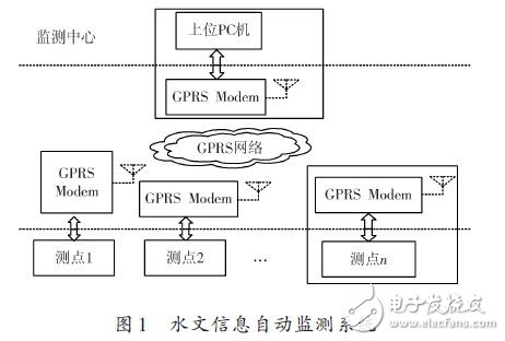
The intelligent information collection terminal in Figure 1 is composed of a single chip microcomputer, a GPRS wireless module, a sensor, a transmitter, etc., and is mainly responsible for collecting water level information and transmitting it to an information synthesis server; the information synthesis server is mainly divided into data reception and transmission, Control management, terminal processing three modules for receiving, processing, storing and displaying data; user terminals include computer user terminals and GPRS mobile phone user terminals. The user who uses the computer terminal needs to install the terminal application on the computer, and then can access the detailed water level data stored in the information integration server on the Internet; after obtaining the authorization, the mobile phone user can obtain the real-time hydrological information through the mobile phone.
The working process of the system is as follows: the information collecting terminal collects the water level data of the site, uses the sensor and the transmitter to convert the data into a standard signal, and then converts it into a digital signal through an analog-to-digital converter (A/D), through the main control program of the single chip microcomputer and The send data subroutine sends the collected data as a short message via a GPRS modem (GPRS Modem). After receiving the short message encoded by the data from the collection terminal, the information integration server processes the water level elevation and related information, and stores it in the database for user's access. Once the user needs it, the transceiver module can be activated, and the water level information and related information in the database will be sent to the user terminal.
The basic functions of the system are as follows:
(1) Automatically collect water level data and store it at regular intervals;
(2) Editing and modifying the basic data and related data manually;
(3) Perform statistical analysis on the collected data and tabulate the drawing;
(4) Using the computer and special software, directly set, debug and monitor the observation sub-station through the mobile phone short message function provided by the GPRS system;
(5) It is capable of remote data transmission.
2 Design of intelligent information collection terminal
2.1 Intelligent information collection terminal hardware
The intelligent information collection terminal hardware is mainly composed of liquid level transmitter, temperature transmitter, connection cable and hydrological information intelligent monitor, as shown in Figure 2.
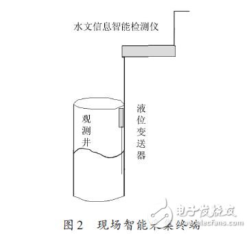
The scheme design uses a corrosion-proof input level transmitter and a platinum resistance temperature transmitter. The front end of the transmitter is made of stainless steel to prevent interference from impurities in the water. The connecting cable is the cable that connects the transmitter to the hydrological information intelligent monitor. Since the pressure level is used in the liquid level measurement, the connecting cable is a dedicated cable with a ventilation duct in the center. The hydrological information intelligent monitor takes the single chip as the core, and cooperates with analog-to-digital conversion, clock chip, data storage, data display, backup power supply and so on.
The working principle of the observation substation is as follows: the liquid level and temperature variables measured by the dispersion at the observation point are converted into a standardized output signal that can be transmitted. The system adopts 4~20 mA current signal transmission mode to send the signal to the analog-to-digital conversion part of the information acquisition terminal to convert the analog signal into a digital signal to reduce signal attenuation and wiring complexity, and then convert the digital signal by the single-chip microcomputer. Analytical processing. The data storage section uses the large-capacity memory chip to store the processed data.
The calendar clock with real-time clock counting also provides accurate date and clock signals to the monitor. The data display part shows real-time monitoring data on site. Finally, the data communication module uses its built-in modem to exchange data between the on-site monitor and the computers of the central water monitoring stations at all levels. The backup power supply unit can ensure the normal use of the monitor when the mains supply cannot be provided normally, and the backup power supply can be automatically switched with the mains.
2.2 Intelligent Information Collection Terminal Software Process
Filtering can filter out specific band frequencies in the signal, which is an important measure to suppress and prevent interference. Based on digital filtering, it has the advantages of high precision, high reliability, programmable change characteristics and easy integration. The system uses digital filtering to improve the realism of the water level sampling signal.
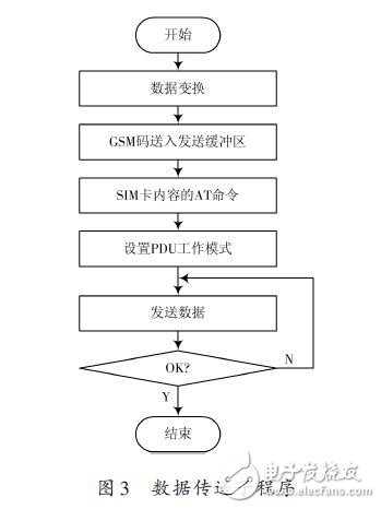
When measuring the water level, the wave impact of rivers, lakes and reservoirs may cause the sampling signal to generate instantaneous and large amplitude pulse interference. Once such interference occurs at the sampling time, the system will not work normally, so the sampled data is filtered. Very necessary. The intelligent information collection terminal adopts a median filtering method, that is, an odd number of data is extracted from the sampling window for sorting, and the sorted median value is used to replace the data to be processed. The system software program arranges "redundant instructions" to make the program out of the normal track due to interference errors in the PC. When the "flying" occurs, the program is quickly put on the right track, and the "software trap" can be arranged to enter the non-flying program. The program area or table area cannot be used to make the program into play when redundant instructions are used. The data collection extension software includes a main program and a data transfer subroutine. The data transfer subroutine flow is shown in Figure 3.
The intelligent information collection terminal software is written in C++ language. The programming structure of object-oriented programming is used to build the main functional components of the application software in the form of components to improve the visibility of the system and facilitate data aggregation and data exchange. Use Microsoft Access database to save and process data to improve system reliability and operational efficiency.
3 Design of information integration server program
The hydrological remote monitoring network system is mainly composed of a central monitoring station and a field observation substation, which are divided into two levels of networking. It consists of three links: on-site data acquisition and storage, remote data transmission, data analysis and database management, as shown in Figure 4.
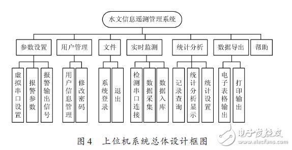
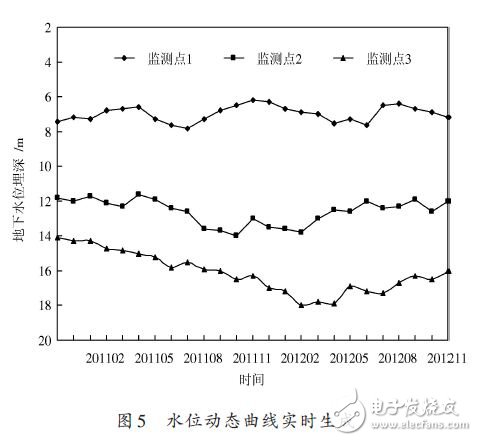
The hydrological information telemetry management system is written in C++ and completes the modular overall design from top to bottom. The system integrates real-time collection, preprocessing, data storage and management functions of water level information, and constitutes an integrated comprehensive information platform. Through the wireless remote transmission technology, the water resource information of the monitoring point is obtained in real time, and the data is stored in the database according to the day, month and year, and the curve is drawn (see Fig. 5) and the histogram is compared and analyzed, and the result is finally displayed. Give users and automatically generate reports according to user needs. The functions of the PC software management system are mainly composed of information integrated management module, real-time remote monitoring module, water resource decision support system, output module and other auxiliary function groups.
3.1 Real-time remote monitoring module
The real-time remote monitoring system uses wireless data transmission technology and serial communication technology to collect data information, and can monitor the operation status of monitoring points at any time, and collect water level and water temperature data in real time. The water level and water temperature sensor of the monitoring point convert the two physical quantity information of water level and water temperature into analog electric signals and transmit them to the measuring instrument. The A/D converts the analog signals into digital signals for data processing and storage. When water resource information is required, the user terminal can send data to the modem connected to it according to the specified communication protocol, and then use the GPRS network to send the data as a short message.
After receiving the short message, the Modem of the monitoring center transmits the received data to the host PC connected to it via the serial port. When the monitoring center needs to collect real-time data, it can send information to the monitoring station via the real-time data acquisition module of the telemetry management system.
3.2 Water Resources Decision Support System
The system uses information fusion technology to analyze and comprehensively process the observation information of multiple sensors. According to the collected information, find and calculate the maximum and minimum values ​​of each year and month water level in each water resource database. The average data and other data were used to establish a model, combined with the current water environment, the status of regional development, and the requirements of the overall planning, combined with the model to comprehensively process and comprehensively analyze the data.
3.3 Output Module
In this part, users can import data into Excel or Word for review or further processing, and automatically generate electronic reports according to the format of their respective needs, including one-day, three-day and five-day reports, which can be printed out by printer.
4 system function expansion and innovation
At present, the system is only used to monitor the water level, but its monitoring terminal provides multiple analog input interfaces, which can realize simultaneous access of multiple signals. That is, while monitoring the water level, the water temperature, flow rate, and the like are measured. The system can realize the remote transmission of data, and is not restricted by environmental conditions. It can be used not only for remote monitoring of water level, but also for remote monitoring of water levels of reservoir dams, river channels, reservoirs, etc. The system conforms to the development trend of GPRS technology and embedded system technology in the monitoring field. It is easy to use, simple in structure, easy to operate and has wide application prospects.
5 Conclusion
With the process of informationization, the hydrological information monitoring system tends to be networked and scientifically developed, requiring the acquisition of hydrological information to be more precise and timely, and the hydrological observation projects and contents are also increasing. The development and application of observation methods and methods and hydrological monitoring technologies are proposed. More and more high requirements. The GPRS-based hydrological information wireless remote monitoring system designed by this scheme is based on the GPRS network (adding GGSN and SGSN to the existing GSM network), and uses the short message method to develop the remote data acquisition system of the single-chip module. Combining long-distance data collection with GPRS wireless data transmission technology has changed the limitations of previous cables, enabling unattended functions of hydrological stations and changing the low accuracy caused by manual monitoring. The system has simple structure, easy to expand, wide network coverage, no geographical restrictions, low communication cost, real-time data online, and can be widely used in geological, hydrological and other fields, and can be applied to remote areas with inconvenient transportation and no power. High application and promotion value. (Author: Daixia Yi, Huoyi Di, Wu Ya-Jing, Li Feng Gu, Zhang exhibition, Zhang Xiaonan)
RCCB named Residual Current Circuit Breaker. When there is human electricity shock or if the leakage current of the line exceeds the prescribed value, Residual current Circuit Breaker/RCCB(without over-current protection) will cut off the power rapidly to protect human safety and prevent the accident due to the current leakage. The rccb switch which made from Korlen electric can be used as infrequent changeover of the line in normal situation.
Korlen electric ---- the rccb switch manufacturer,produces types of Residual Current Circuit Breaker. It is applicable to industrial site, commercial site, tall building and civil house.
Residual Current Circuit Breaker
Residual Current Circuit Breaker,Ac Residual Current Circuit Breaker,Miniature Residual Current Circuit Breaker,Residual Current Electrical Circuit Breaker
Wenzhou Korlen Electric Appliances Co., Ltd. , https://www.korlenelectric.com